The Unlikely Record · Episode 06 · Twelve stories
Twelve journeys that changed when their travelers met the world
A route begins as a proposal. Weather, timing, knowledge and the limits of a record decide what happens after departure. These twelve stories follow travelers whose plans changed, along with the watches, messages, testimony and physical traces that let us examine their journeys. Some reached the intended place by an unexpected method. Others returned with a different achievement, or left evidence for people much later to interpret.
Story 01
California, by Way of Ireland

Douglas Corrigan announced a flight from New York back to California. His next arrival was in Ireland. In July 1938, the pilot and his aging Curtiss Robin crossed the Atlantic while his declared destination lay in the opposite direction. Corrigan maintained that clouds and a navigation mistake had sent him the wrong way.
That explanation needs its own label. Aviation authorities had already refused him permission for an Atlantic crossing, and he had rebuilt and modified the aircraft for long-distance flying. The journey happened; an innocent compass error was his defense.
The unauthorized arrival made Corrigan famous. His pilot’s license was suspended, and he returned across the ocean aboard a liner. At home, a New York ticker-tape parade, a White House visit, and a national tour turned the breach of regulations into a public performance. Cities gave him joking presents, including compasses.
The nickname kept the apparent mistake permanently attached to the achievement. Every retelling points west toward the announced destination and east toward the actual landing. The space between those two routes is also the space between a demonstrable flight and an explanation that its pilot refused to surrender.
Evidence and sources
The flight is documented; Corrigan’s explanation that he accidentally flew east remains a disputed claim. The NPS page gives inconsistent penalty descriptions, so no exact suspension length is asserted.
- Douglas Wrong Way Corrigan — National Park Service
Story 02
A Message That Looked Undisturbed

On April 21, 1861, Burke, Wills and King returned to their Cooper Creek depot. The supporting party had left only hours earlier. William Brahe had waited longer than the planned three months, then buried supplies and a message before departing. The returning men found the cache, but the meeting that should have happened beside it had already been missed.
They chose a new route toward Mount Hopeless rather than following Brahe or remaining at the depot. They also left a message beneath the tree. According to the National Museum of Australia, they concealed the disturbance so carefully that Aboriginal people would not find it. Concealment then worked against its authors.
Brahe returned with William Wright on May 8. Seeing no convincing sign of a visit, they did not uncover the message. When Wills came back later that month, he in turn found no indication that the searchers had returned. The same depot had become three separate journeys, with each party unable to read the others’ presence.
Burke and Wills died in late June. King survived through the support of the Yandruwandha people and was found by a relief party in September. His survival belongs beside the failed messages: help existed in the country around the depot, as well as in the expedition’s distant supply chain.
Evidence and sources
The failed rendezvous and later visits are documented. The familiar inscription is not treated as an independently verified surviving 1861 carving, and no speculative medical cause is assigned.
- Burke and Wills — National Museum of Australia
- Melbourne’s first monument: Charles Summers’ Burke and Wills — State Library Victoria, La Trobe Journal
Story 03
A Colony at the Wrong River
La Salle wanted to establish a French colony at the mouth of the Mississippi. Instead, his expedition reached the Texas coast. Texas Historical Commission archaeologist James Bruseth explains the mistake in terms of faulty maps: La Salle believed he was near the river he wanted, while his ships had reached a different part of the Gulf.
In 1685, the colonists built a settlement on Garcitas Creek, later known as Fort St. Louis. Their position on the ground did not match the strategic place they had meant to occupy. When La Belle sank in Matagorda Bay in 1686, the expedition lost another means of movement and supply. An intended gateway into a continental river system had become an increasingly isolated settlement.
By January 1687, a community initially numbering about 150 had dwindled to roughly forty. La Salle set out with seventeen men to try to reach distant French posts in the Great Lakes region. Those remaining faced an extremely precarious situation; Karankawa people attacked the fort in the winter of 1688–89.
Centuries later, excavation made the failed colony materially visible again. Archaeologists recovered La Belle’s hull and cargo and investigated the settlement itself. These objects reveal what the colonists brought for a planned future. They also show how far an expedition’s preparations could become separated from the place where it actually landed.
Evidence and sources
The intended Mississippi colony, Texas landing and settlement are established by archaeological research. Faulty maps are an institutional explanation, not a claim that one isolated mistake caused every later death.
- La Salle Archeology Projects — Texas Historical Commission
- The Medallion, Spring 2021 — Texas Historical Commission
Story 04
The Watch Expected Land First
A watch can measure a journey without telling its wearer which way to turn. John Harrison’s H4 carried that possibility to sea in 1761, when his son William took the timekeeper on a trial voyage to Jamaica. Dependable timekeeping helped establish longitude at sea.
On the outward crossing, William used H4 to predict that Madeira would appear sooner than the crew expected. Royal Museums Greenwich records the captain’s favorable reaction: he wanted to buy the next timekeeper. Land provided a check on the prediction.
The voyage did not end the argument. Back in England, the Commissioners of Longitude considered the trial insufficient. Another test followed at Barbados in 1764, where astronomical observations could establish a position against which competing methods could be judged. The disagreement concerned what counted as adequate proof, as well as how well Harrison’s watch worked.
In 1765, the Board confirmed performance within the strictest limits of the earlier Longitude Act. Payment nevertheless came with conditions, including explaining the mechanism and demonstrating that other makers could reproduce such instruments. A successful arrival was one achievement; turning a remarkable watch into a repeatable navigational method required a different kind of journey.
Evidence and sources
Royal Museums Greenwich documents H4’s sea trials and the dispute over proof and payment. The story does not portray the first successful trial as an immediate universal solution or full prize award.
- Longitude found: the story of Harrison’s timekeepers — Royal Museums Greenwich
Story 05
Two Directions Around the Same World

Nellie Bly left for an eastward journey around the world on November 14, 1889. That evening, Elizabeth Bisland departed westward. Bly was traveling for the New York World; Bisland’s editor at Cosmopolitan had hurriedly organized a rival attempt. A challenge inspired by Jules Verne’s fictional eighty-day journey had become a competition between two working journalists.
The route itself was a contestant. Steamship departures, railway connections and weather determined when either woman could move. Bly even fitted in a visit to Verne in France. Their journeys depended on an established transport network, but moving through it quickly required coordinating many separate services across the globe.
Bly completed her circuit on January 25, 1890, after a little over seventy-two days. Bisland took about seventy-six. Her journey ended with a stormy Atlantic crossing aboard Bothnia. Finishing second in that contest still meant completing a circuit faster than the fictional traveler whose schedule had helped inspire it.
A small globe in the Science Museum Group collection preserves Bisland’s route. It also marks steamship timings and submarine telegraph cables, placing a personal journey among the connections that made it possible. The museum has not established who commissioned the globe. Its surviving line nevertheless gives the less-remembered traveler a place on the map, beyond the simple announcement of a winner.
Evidence and sources
The two journeys and opposite directions are documented. Institutional accounts differ on exact finish-day wording; the narrative uses the firmly established Bly date and approximate elapsed durations, without a claim of sabotage.
- Nellie Bly: Around the World — Heinz History Center
- Nellie Bly: Digital Resources — Library of Congress
- Elizabeth Bisland: Around the world in 76 days — Science Museum Group
Story 06
The Ocean Was the Instrument

Hōkūleʻa left Honolua Bay on May 1, 1976, with a destination thousands of miles away and no modern navigation instrument directing the outward passage. Mau Piailug, a master navigator from Satawal in Micronesia, guided the canoe. Kawika Kapahulehua served as skipper. Their journey put a demanding proposition into practice: an ocean could be crossed through skilled observation rather than accidental drift.
Mau read stars, winds, waves and other signs of the sea. The Polynesian Voyaging Society’s archive emphasizes that this route took him farther than he had previously voyaged and south of the equator, beyond the North Star’s usefulness as a familiar guide. The knowledge was extensive and learned, rather than an unexplained instinct.
The canoe reached Mataiva in the Tuamotu Archipelago on June 1 and arrived at Papeʻete Harbor on June 4. Thousands gathered to welcome it. For the society and its participants, the crossing gave visible form to a voyaging heritage whose sophistication had been underestimated.
There is an important limit to the celebratory summary. Mau did not navigate the return passage to Hawaiʻi; modern instruments were used on that leg. The outward achievement stands on its own. A successful demonstration did not reproduce every ancient voyage, but it showed the practical force of knowledge carried by a living teacher.
Evidence and sources
The voyage and its non-instrument outward navigation are documented by the organizing society and participant recollections. It demonstrates navigational capacity, not the exact itinerary of every ancient migration.
- Searching for a Way: The First Voyage to Tahiti, 1976 — Polynesian Voyaging Society
- Fiftieth Anniversary of Hōkūleʻa’s 1976 Maiden Voyage to Tahiti — Polynesian Voyaging Society
Story 07
Wednesday on Board, Thursday Ashore
When the surviving ship Victoria reached Cape Verde in July 1522, its crew needed provisions. A second question went ashore with the boat: what day of the week was it? Antonio Pigafetta’s account says the inhabitants answered Thursday. The voyagers’ record said Wednesday.
Pigafetta was particularly surprised because he had kept a daily record. Had he missed a day? He later explained it through the expedition’s westward journey around the earth. Their count of local days had accumulated a difference from the calendar kept by people who stayed in one place.
The account places this discovery inside a much more dangerous stop. The crew tried to conceal the expedition’s true circumstances from the Portuguese authorities while obtaining rice. Men sent ashore were detained, and the ship left without them. A striking lesson about time did not suspend the immediate problems of hunger, rivalry and survival.
Victoria reached Sanlúcar in September, completing the circuit begun by Magellan’s expedition. Magellan himself had died before the return. The calendar story belongs to the survivors. It reveals a difficulty in describing a round world with a sequence of ordinary dates: a careful diary can still need a rule for bringing its count home.
Evidence and sources
Pigafetta and Albo describe the day discrepancy in contemporary voyage accounts, read in an 1874 translation. This is not evidence of a lost physical day or Magellan personally completing the voyage.
- The first voyage round the world, by Magellan; translated accounts, 1874 — Hakluyt Society; Project Gutenberg transcription
Story 08
The Tree Rings Supplied a Year
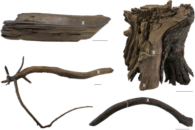
The traces at L’Anse aux Meadows gave a Norse Atlantic crossing a place on the ground. Recognized in 1960, the Newfoundland site preserves evidence of buildings, iron working and boat repair. Archaeology established a presence; it could not simply attach every detail of a later saga to the people who had lived there.
In 2021, researchers supplied an unusually precise year. Their study examined wooden objects associated with the Norse occupation and cut with metal tools. Three came from different trees. Each retained enough of its growth sequence to connect a known atmospheric radiocarbon event in 993 with the wood’s outer edge.
Once that distinctive marker had been located, the remaining rings provided a count. The study placed the cutting of the three trees in 1021. This narrowed one documented activity to a particular year, where older radiocarbon estimates had produced much broader ranges. The precision came from combining an unusual natural event with the ordinary annual growth of trees.
That result has clear boundaries. It does not name the person holding a tool or establish the settlement’s first day. It does not turn Leif Erikson’s possible connection into an identification. What it offers is smaller and firmer: people associated with the Norse site were working wood in Newfoundland in a year that can now be stated.
Evidence and sources
The 2021 study dates wood cutting associated with Norse occupation to 1021. It does not identify Leif Erikson, the settlement’s founding year, or the exact duration of occupation.
- L’Anse aux Meadows National Historic Site of Canada — Parks Canada
- Evidence for European presence in the Americas in AD 1021 — Kuitems et al.; Nature
Story 09
News the Searchers Did Not Want
John Rae was mapping in the Canadian Arctic in 1854 when Inuit accounts brought him news about the missing Franklin expedition. The information described a disastrous ending for men who had set out to find a Northwest Passage. It also included evidence of cannibalism among the starving survivors.
Some British readers accepted extreme hunger as an explanation; others rejected the evidence. Charles Dickens publicly denied that Franklin’s men could have behaved that way. Information could reach authorities and still fail to become accepted knowledge.
Later archaeological work supplied another kind of record. Studies of bones collected on King William Island found cut marks consistent with cannibalism. Historic England’s further examination reported breakage and polishing consistent with attempts to obtain remaining nourishment. These findings supported the substance of testimony that had been disputed in the nineteenth century.
The story cannot provide a complete sequence of the expedition’s final days or assign particular actions to every man. It can show why listening mattered. Inuit knowledge was evidence about a landscape and events within it, not merely an obstacle to a preferred heroic account. Rae’s return brought a report; accepting what it said proved a much slower journey.
Evidence and sources
Rae’s report and hostile reception are documented; later bone research supports the reported survival cannibalism. Individual acts or causes of death cannot be reconstructed for every expedition member.
- Historic England Research Sheds New Light on Franklin Expedition — Historic England
Story 10
The Rescue Had to Find Its Way Back
Batavia struck a reef in the Houtman Abrolhos on June 4, 1629. The ship had been carrying people and goods toward the Dutch East Indies. Its survivors reached nearby islands, but getting off the wreck did not solve their most immediate problem: the places where they had landed lacked dependable fresh water.
Commander Francisco Pelsaert, skipper Ariaen Jacobsz and others left in the surviving boat to search for it. When the search failed, the voyage expanded into a journey to Batavia, the colonial port now called Jakarta. The Western Australian Museum records their arrival there on July 7. A small boat had completed a passage that was never meant to replace the ship’s original journey.
Returning with help was another undertaking. Pelsaert came back aboard Sardam in September to recover survivors and valuable cargo. During his absence, Jeronimus Cornelisz and his followers had murdered many of the people stranded on the islands. A group associated with the soldier Wiebbe Hayes had resisted them and found water and food.
Pelsaert’s surviving journal records both the wreck and the subsequent proceedings. It requires care as the account of a commander explaining a catastrophe. The rescue voyage nevertheless reveals the double problem of distance: reaching a port was only half the task. Help still had to retrace the route to people whose circumstances were changing while it traveled.
Evidence and sources
The longboat voyage and rescue return are documented. Museum sources give varying passenger totals, omitted here. The commander’s own account is evidence from a participant with an interest in explaining his conduct.
- Batavia’s history, 1628–1963 — Western Australian Museum
- Batavia: Strangers on the Shore — Western Australian Museum
- The Batavia Journal of Francisco Pelsaert, 1629 — Western Australian Maritime Museum translation
Story 11
The Logbook Came in the Boat
When the Bounty mutineers forced William Bligh into a launch on April 28, 1789, eighteen other men went with him. Among the few things saved was a written record. His clerk had preserved the journals, while maps, drawings and the timekeeper could not all be brought away. The officer lost his ship but retained the means to describe what followed.
At Tofua, a search for provisions ended in violence and the death of John Norton. The remaining men then attempted the long passage toward Timor. In his published account, Bligh said he navigated without a chart, using recollection, regional knowledge, and a book of latitudes and longitudes. That is his explanation, preserved alongside his detailed observations.
The logbook records weather, rationing and the work of keeping the heavily loaded boat afloat. Stops near northern Australia offered brief opportunities to obtain food. On June 14 the survivors reached Timor. Arrival ended the open-boat passage, although illness continued to take lives afterward.
The journal was more than a travel souvenir. Bligh understood that his conduct would be judged, and the surviving record helped him present his case. Reading it means following both a route across the sea and a participant’s effort to establish what had happened to him. Its detail is valuable without making its author an impartial narrator.
Evidence and sources
Bligh’s log and letter document the launch journey from his perspective. His survival and record keeping do not settle every dispute about his command or supply other participants’ unrecorded thoughts.
- William Bligh’s Bounty logbook — State Library of New South Wales
- Letter from William Bligh to Elizabeth Bligh, August 19, 1789 — State Library of New South Wales
- A Narrative of the Mutiny, on Board His Majesty’s Ship Bounty (1790) — William Bligh; George Nicol, London; Project Gutenberg transcription from Posner Memorial Collection scans
Printed pages 24–26; title page identifies 1790 edition.
Story 12
The Ice Chose the Route

The plan was to cross Antarctica. Endurance would carry Shackleton’s party toward the continent from the Weddell Sea, making a starting point for a journey on foot. Instead, ice trapped the ship in early 1915. The expedition’s position began changing with the pack, while the intended overland route remained unreachable.
The men abandoned the damaged ship in October. It sank on November 21, leaving them with supplies and small boats on the drifting ice. The route was now a sequence of possible escapes rather than a line chosen before departure. Reaching land became the immediate objective.
In April 1916, three boats carried the party to Elephant Island. From there, Shackleton and five companions took James Caird across the Southern Ocean toward South Georgia. Reaching that island still left a mountain crossing before help could be summoned. The remaining men on Elephant Island were rescued in August; all twenty-eight members of the Endurance party survived.
Surviving equipment and records make the changes of plan concrete. The Scott Polar Research Institute holds navigation instruments and a memory map by Frank Worsley showing the South Georgia crossing. These are traces of successive decisions under constraint. The celebrated rescue did not accomplish the original Antarctic crossing, but it brought the people following that abandoned plan back alive.
Evidence and sources
The Weddell Sea party’s drift and rescue are documented. The survival claim is limited to the 28 people aboard Endurance, not every participant in the wider Trans-Antarctic Expedition.
- Shackleton: Antarctic Endurance Expedition 1914–1916 — Royal Meteorological Society
- By Endurance We Conquer: Shackleton and his Men — University of Cambridge, Scott Polar Research Institute
The route drawn afterward can make a journey look inevitable. Its records preserve the uncertainty: a missed meeting, a disputed explanation, an observation that others would not accept. Following those records allows the destination and the decisions along the way to remain part of the same story.
About the evidence labels
Documented identifies a supported historical event. Disputed marks an account whose explanation or details remain contested. Folklore identifies a recorded tradition; its inclusion does not establish that a supernatural event occurred.


