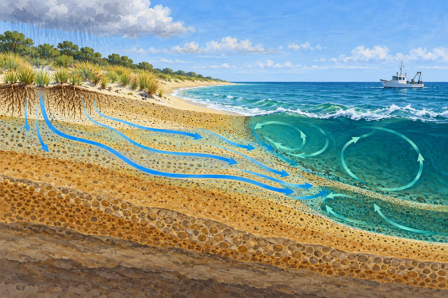
A coastline looks like a boundary: land ends, sea begins. Underground, the boundary is a zone of exchange. Fresh groundwater can move toward the sea, while seawater can enter coastal sediment, react there, and return.
Submarine groundwater discharge includes this hidden outward flow. Its importance is not limited to the amount of fresh water delivered. A relatively modest water flux can carry a substantial chemical flux if the water has acquired concentrated nutrients, metals, or other dissolved material below ground.
Groundwater is not always fresh
The USGS definition includes fresh groundwater, recirculated seawater, and mixtures of both. That distinction prevents an easy mistake: treating every estimate of submarine groundwater discharge as a new freshwater contribution to the ocean.
Rain-fed terrestrial hydraulic gradients can drive water seaward. Tides, waves, and density differences can also move seawater through the seabed. These processes may coexist, and their relative importance changes with geology and coastal conditions.
The aquifer need not be a cavern containing an underground river. Much coastal flow occurs through pores or fractures. A beach can therefore exchange water across a broad area without a visible spring announcing where the discharge takes place.
The water changes while it is hidden
Subsurface contact with minerals, organic matter, and microbes can alter dissolved substances. Recirculated seawater is consequently not chemically identical to seawater that simply waited offshore for the same time.
WHOI’s Coastal Groundwater Geochemistry group investigates how these exchanges influence nutrients and trace elements. Its research combines field sampling and laboratory analysis because the chemical outcome depends on the setting, not just the direction of flow.
A nutrient-rich discharge can affect coastal ecosystems, but “groundwater” is not synonymous with “pollution.” Some chemical inputs are natural; some reflect land use or wastewater; some are modified by reactions along the flow path. Identifying the source requires evidence for the particular constituent.
How do you measure a flow you cannot see?
Researchers can combine seepage measurements, temperature patterns, salinity, geophysics, hydraulic models, and chemical tracers. No one technique is a universal meter for every coast. A patchy seafloor and a changing tide can make a small direct sample unrepresentative of the larger shoreline.
Radon and radium isotopes are useful natural tracers because groundwater and sediment porewater can be enriched relative to surrounding seawater. A USGS review of these tracers explains how concentration patterns and transport models are combined to infer exchange rates.
The isotopes are not poured into the sea for this purpose. Researchers use naturally occurring contrasts. A higher tracer concentration signals a possible connection with subsurface fluids, while the quantitative flow estimate requires a mass balance.
A bathtub balance with an extra complication
Imagine an idealized coastal box. To keep its tracer inventory steady, inputs must balance outputs and decay. Groundwater may supply tracer, but mixing with offshore water, loss to the atmosphere for a gas such as radon, and radioactive decay remove it. Sediment sources may contribute too.
If you measure only the inventory and ignore a large loss term, you can underestimate the input needed to sustain it. If the groundwater end-member concentration is wrong, dividing the tracer input by that concentration gives a wrong water flux.
Research specifically addressing radon uncertainties identifies variable groundwater concentrations, atmospheric evasion, and mixing losses as important questions. The tracer is valuable because its behavior can be modeled and tested, not because one elevated reading uniquely solves the water budget.
A worked chemical-flux comparison
Consider two hypothetical discharge pathways. Path A supplies 100 cubic meters per day carrying 1 milligram per liter of a nutrient. Path B supplies 10 cubic meters per day carrying 20 milligrams per liter. Since a cubic meter contains 1,000 liters, their nutrient loads are 100 grams per day and 200 grams per day respectively.
The smaller water flux carries the larger chemical load. These invented values are a unit exercise, not a claim about a real site. They show why both concentration and flow must be measured, and why a water-volume ranking need not match an ecological-input ranking.
The load still does not determine ecosystem response by itself. Mixing, residence time, nutrient limitation, season, and biological uptake influence what happens after the water emerges. A flux estimate is one link in the causal chain.
Write a second balance for freshwater alone and a third for the nutrient. Seawater recirculation can contribute strongly to the total discharge while adding little new freshwater. Reactions underground can also change the nutrient concentration without changing the same amount of water. The three balances describe connected processes but should not be forced to have identical arrows or totals. That distinction is useful well beyond groundwater whenever a moving fluid carries a substance that can react along the way.
A real dataset makes the sampling visible
USGS observations from Florida’s Indian River Lagoon include radon and physical water-column measurements. Their documented locations and times show the kind of context needed to interpret a coastal survey.
Before comparing values, identify the measurement units, tidal stage, salinity, water depth, and whether the survey followed a moving boat or a fixed time series. A changing concentration can reflect changing dilution as well as changing discharge.
A useful reader exercise is to draw three arrows on a coastal cross section: fresh groundwater outward, seawater into sediment, and mixed porewater outward. Then write a separate chemical concentration beside each. The diagram immediately becomes more informative than one blue arrow labeled “underground river.”
The shore is a reactor as well as a boundary
Coastal management often begins with rivers and visible outfalls because they are easier to map. Groundwater exchange asks for a wider accounting. The land-sea interface extends through sediment and rock, and its chemistry can remember processes upstream and underground.
Once that exchange is made visible in a model, an apparently quiet beach becomes more interesting. Water is crossing the boundary on routes too small or diffuse to watch directly, carrying evidence of where it has been.
Sources and a next step
- USGS: submarine groundwater discharge definition and processes
- WHOI: coastal groundwater geochemistry
- Smith: natural radium and radon tracers
- Burnett et al.: radon tracer uncertainties
- USGS: Indian River Lagoon radon and water-column dataset
Continue exploring art, ideas, and unexpected connections at Incoprea.